Learning Resources

Resource Type
Audience
Resource Tags

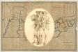
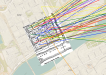
Interactive map: Destruction of Tennessee's African American Neighborhoods

Screenshot -Destruction of Tennessee African American Neighborhoods
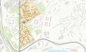
A series of interactive maps that illustrate the destruction of Tennessee's Black neighborhoods, including the community demolished for the contraction of James White Parkway in Knoxville.
Access More Details

Interactive map: Historic images of structures removed by Urban Renewal in Knoxville

Logo - East Tennessee History Center
An interactive map that geolocates historic images of structures removed as part of the Riverfront-Willow Street Urban Renewal project in Knoxville, Tennessee, beginning in the mid-1950s.
Access More Details

Interactive map: Pre-Urban Renewal Knoxville, 1953

Screenshot - Mapping Black Removal in Knoxville
An interactive map of properties located within the Riverfront-Willow Street and Mountain View Urban Renewal projects, as sourced from the 1953 Knoxville, Tennessee, city directory.
Access More Details

KGIS (Geographic Information System)

Knoxville Geographic Information System
Provides maps, historical aerials, address searches and property owner reports, school zones, voting districts and elected officials, and more.
Access More Details

Knox County Map, 1870's

Knox County Archives
Digitized from the Knox County Archives collection.
Access More Details

Knox County Map, 1895

Library of Congress
Includes population, school enrollment, county officials, land ownership.
Access More Details

Knoxville City Engineering Maps, 1926, Wards 1 thru 26

Knox County Archives
Digitized from the Knox County Archives collection.
Access More Details

Patriot Paths

Logo - Patriot Paths
An interactive map that utilizes American Revolutionary War pension records to chart the paths that Tennessee soldiers took before and after their service.
Access More Details

Sanborn maps collection of Library of Congress

Library of Congress
Sanborn maps from the Geography and Map Division of the Library of Congress.
Access More Details

StoryMap: Knoxville Origins

1791 Knoxville Land Lottery ArcGIS
Chronicles the founding of the city and includes an interactive map that traces immigration patterns of participants in the 1791 Knoxville Land Lottery.
Access More Details

Tennessee Historic Cemeteries Viewer

Logo - Tennessee Historical Commission
An interactive map of the 31,000+ documented historic cemeteries in Tennessee.
Access More Details

Tennessee Sanborn Maps 1867-1970

ProQuest Digital Sanborn Maps 1867-1970
Fire insurance maps capture changes in Tennessee cities.
Access More Details